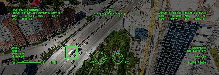
BAE Systems’ Geospatial eXploitation Products™ (GXP®) group is excited to announce the integration of Movement Intelligence (MOVINT) capabilities, including multi-source tracking analytics, into its line of geospatial software. Leveraging BAE’s Tracking Analytics Software Suite (TASS), these new capabilities interpret movement and activity from a variety of sources including Wide Area Motion Imagery (WAMI), Full Motion Video (FMV), and Ground Motion Target Indicators (GMTI), enabling analysts to efficiently track people, vehicles, and other objects of interest across an entire field-of-view.
Eliminating the need for manual analysis of large volumes of motion imagery sourced from multiple sensors, GXP’s enhanced tracking analytics allow users to focus instead on exploring and interpreting threat activity and networks while creating actionable intelligence reporting.
“Our advanced Movement Intelligence capabilities allow sensor operators to monitor multiple feeds across many regions,” said Dana Poirier, General Manager of the Geospatial eXploitation Products™ group. “Advanced MOVINT and tracking analytics enable our customers to identify critical targets, activities, and emerging situations much more effectively than previous ISR solutions.”
The simultaneous tracking and indexing of all movers in a region enables analysts to rapidly discover key trends, anomalies, and emerging threats often concealed in traditional analysis. In addition, target object classification, real-time event detection, and automated watchbox alerts provide further detail and insight.
Expanding upon GXP’s current suite of geospatial solutions, these new MOVINT capabilities deliver unmatched situational awareness, intelligence, and insight for critical activities such as border security, counter-terrorism, drug interdiction, and the protection of high value infrastructure.
BAE Systems’ Geospatial eXploitation Products (GXP)
BAE Systems’ Geospatial eXploitation Products™ (GXP®) deliver an unrivaled capability for discovery, exploitation, and dissemination of mission-critical geospatial intelligence. From key military, security, and incident response operations to commercial and international deployments, GXP provides the most comprehensive suite of geospatial analysis solutions supporting timely and effective decision-making.
For more information, please contact:
Greg Good
Director of Marketing
Geospatial eXploitation Products
Email: gregory.m.good@baesystems.com
Phone: 858.592.5672