Introducing GXP Xplorer® Disconnected, the most advanced solution for managing and utilizing intelligence data on deployable systems
Ideal for remote workgroups, the GXP Xplorer Disconnected software solution generates a catalog of both geospatial and non-geospatial data so you know exactly what imagery and information is available when operating in a compromised environment.
While operating with connectivity, users can continuously synchronize data from a parent GXP Xplorer instance to their deployable machines based on geospatial boundaries and/or other metadata fields. Users can then rapidly search, filter, and load this information while deployed, regardless of connectivity, in order to create actionable intelligence in the field. This intelligence can be shared with additional team members as all similarly deployed personnel can search and discover common data contained within the GXP Xplorer Disconnected catalog.
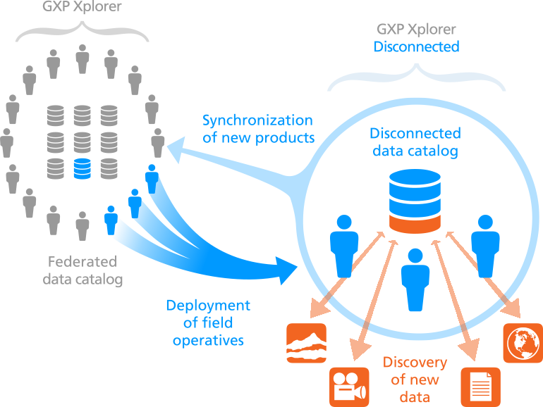
The GXP Xplorer Disconnected solution functions as a desktop application with an intuitive user interface similar to the GXP Xplorer application. A timeline illustrates when data was collected, and searches can be performed with a variety of additional filters including sensor type, collection angle, and free text within documents and geospatial metadata. Search results can be viewed over a map background so users can see precisely what information is available over an area of interest, while a list view provides additional visibility into non-geospatially tagged information.
The GXP Xplorer Disconnected solution allows you to deploy a small number of seats from within a larger federated system and take a select catalog of data into the field. Once the deployed team returns, any data and/or products developed in the field are incorporated back into the complete GXP Xplorer catalog.
The GXP Xplorer Disconnected software solution is utilized by both all-source and image analysts at organizations across the world:
- First responders / humanitarian relief personnel in environments with limited or no connectivity
- Deployed military units needing access to intelligence products in the field
- Field technicians / engineers needing access to schematics and imagery to increase productivity
- Drone operators needing a way to catalog and access historical imagery as well as newly collected data
Any data and/or products developed in the field are incorporated back into the complete GXP Xplorer catalog.