GXP OpsView® v2.6
Ensuring safety and security through advanced operational planning and incident response

Request additional info or a product demo
GXP OpsView® Capabilities
Strategic planning and simplified communications with a Common Operating Picture (COP)
Enables effective mission command
Enabling mission command to effectively coordinate field operators in real time throughout an operation, event, or crisis situation, the GXP OpsView solution provides:
- Situational awareness and operational visibility via Collaborative Response Graphics® (CRG®).
- Real-time location sharing layered on top of the CRG
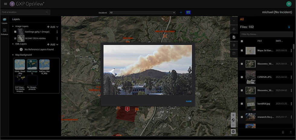
- Field data uploads including photo files
- Enhanced coordination and collaboration tools
- Rapid tasking and deployment of field personnel
From an efficient dashboard view enabling strategic management of multiple operations, to a focused incident view supporting asset deployment and real-time communications, the GXP OpsView solution brings an unrivaled degree of command and control to operational planning and tactical response.
The GXP OpsView software solution provides critical planning and response support for:
- Active assailants, terrorist attacks, and hostage situations
- Emergency management and disaster relief
- Wildland firefighting and prevention
- Search and rescue operations
- Drug Interdiction and high-risk warrants
- Private security for corporate offices, industrial facilities, and events
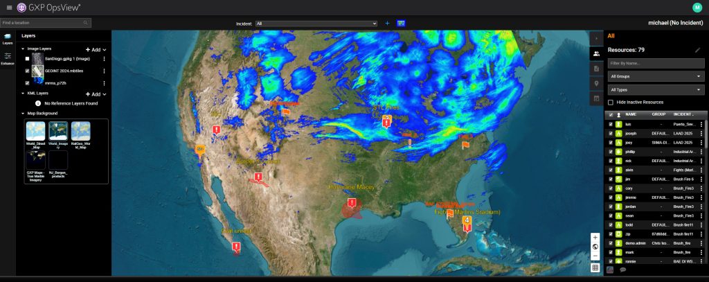
Dashboard view for operations oversight
Providing a strategic view of your entire organization, the GXP OpsView Dashboard provides oversight into all active incidents in real-time while providing access to historical incidents for reporting, review, forensics, and training.
- COP of all active incidents via list and map views
- Content overlays on the map view via standards-based data sharing
- Rapid identification of all responders and available resources
- Simplified communication with field personnel
- Strategic viewpoint for executing operational strategy across all activity
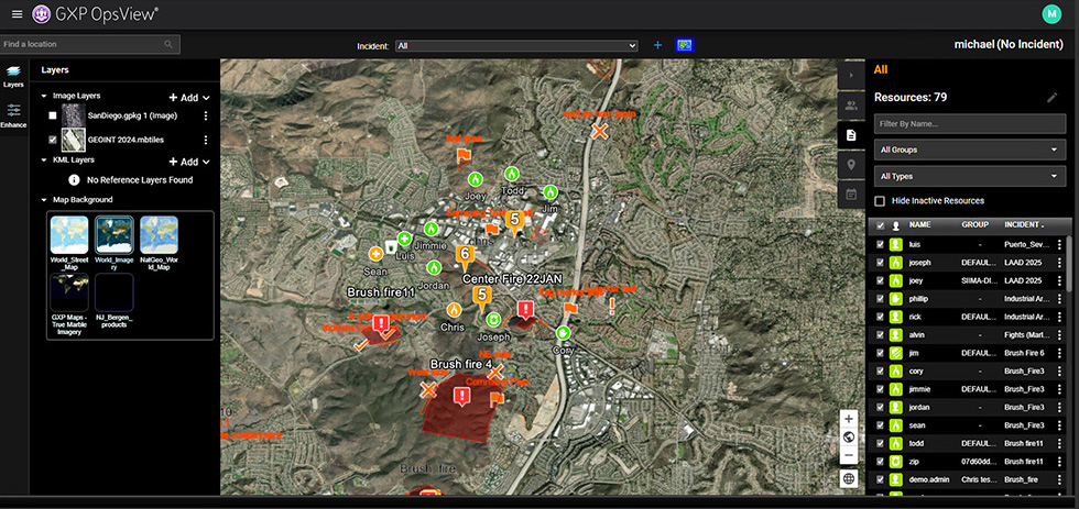
Incident Detail view for efficient response
The Incident Detail view allows users to drill down into a specific incident to see details regarding personnel, tasking, operation files and content, and communications.
- Multi-layered CRG
- Teaming tools for rapid execution of Incident Command best-practices
- Real-time tracking with bread crumbs for previous asset location
- Enterprise-wide sharing of incident data
- Uploads of field data (including photos)
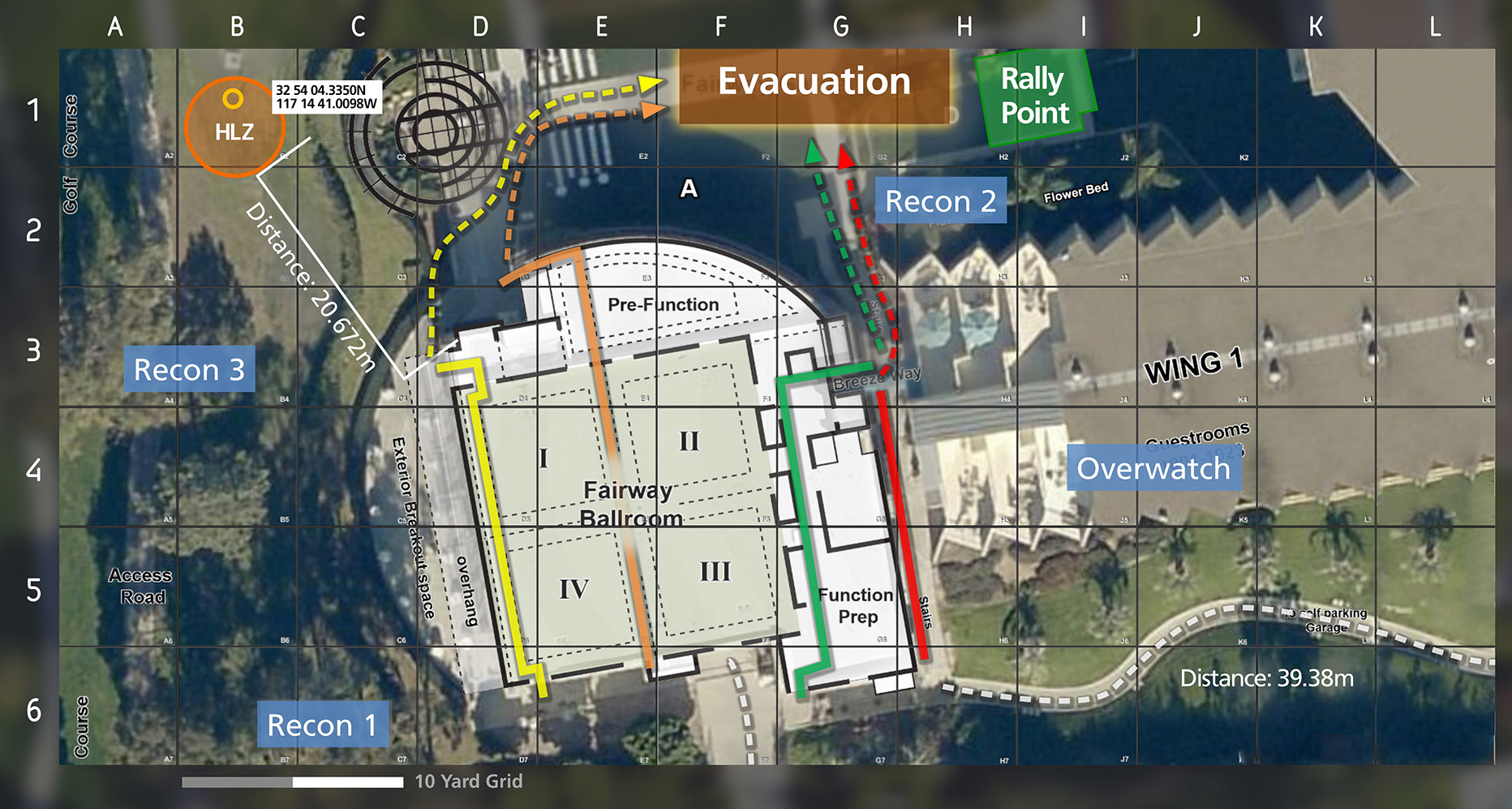
CRGs provide a common operating picture
CRGs provide a common operating picture and an accessible visual representation of an emergency action plan for all response personnel including:
- Gridded Reference Graphics overlaid onto current site maps
- Precise measurements of distance and elevation, degree of slope, and line of sight
- Critical data including staging areas, evacuation zones, vantage points, hazards, and roadblocks
- Real-time tracking of response personnel via mobile devices
- Data-agnostic support for imagery registration and overlays onto the plan
GXP® Ecosystem
Providing the foundation for development of the most advanced geospatial intelligence, the GXP Ecosystem delivers an unrivaled capacity for discovery, exploitation, and dissemination of mission‑critical geospatial and temporal data.