GXP WebView® v2.6
Rapid visualization and analysis of geospatial data, enabling the development of actionable intelligence
Request additional info or a product demo
Software Solution Overview
A web browser-based Electronic Light Table (ELT) enabling image exploitation, aggregation and overlay of supplemental data layers, and robust product generation coupled seamlessly with GXP Xplorer® data discovery and management capabilities.
Stream, exploit, and publish
Built for both the all-source and image analyst, GXP WebView® software supports simple, accurate data visualization and analysis, as well as the development of effective and actionable geospatial reports.
Taking full advantage of comprehensive pixel streaming technology, GXP WebView software enables imagery to be streamed at full resolution and with complete metadata to support rigorous sensor model initialization. Analysts can take advantage of this best-in-class accuracy with tools for height mensuration, shadow measurement, and more, while elevation data can be automatically loaded to ensure accuracy in all three dimensions.
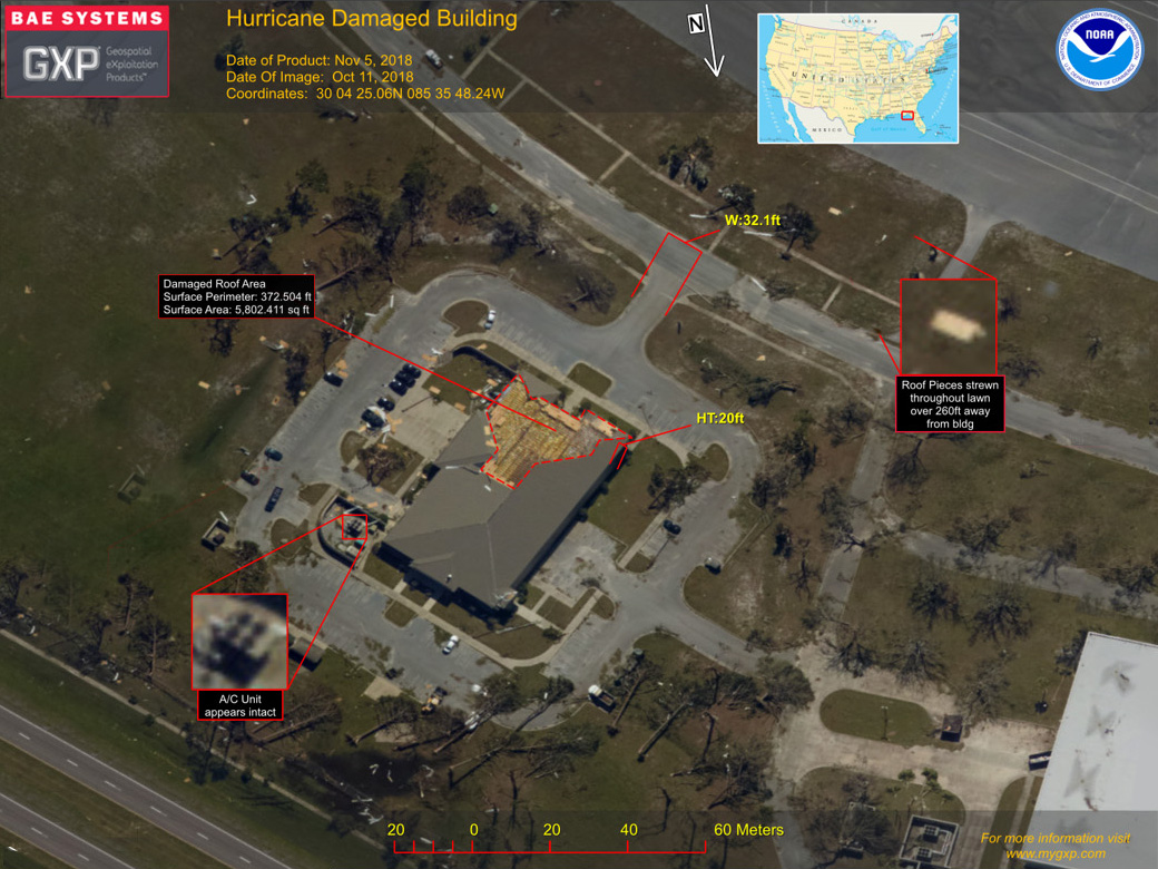
GXP WebView product generation can be customized using templates to provide contextual information, and a variety of output formats are available including Microsoft® PowerPoint®, PNG, JPG, and more. Products can be shared out via GXP Xplorer software for rapid intelligence distribution to key stakeholders.
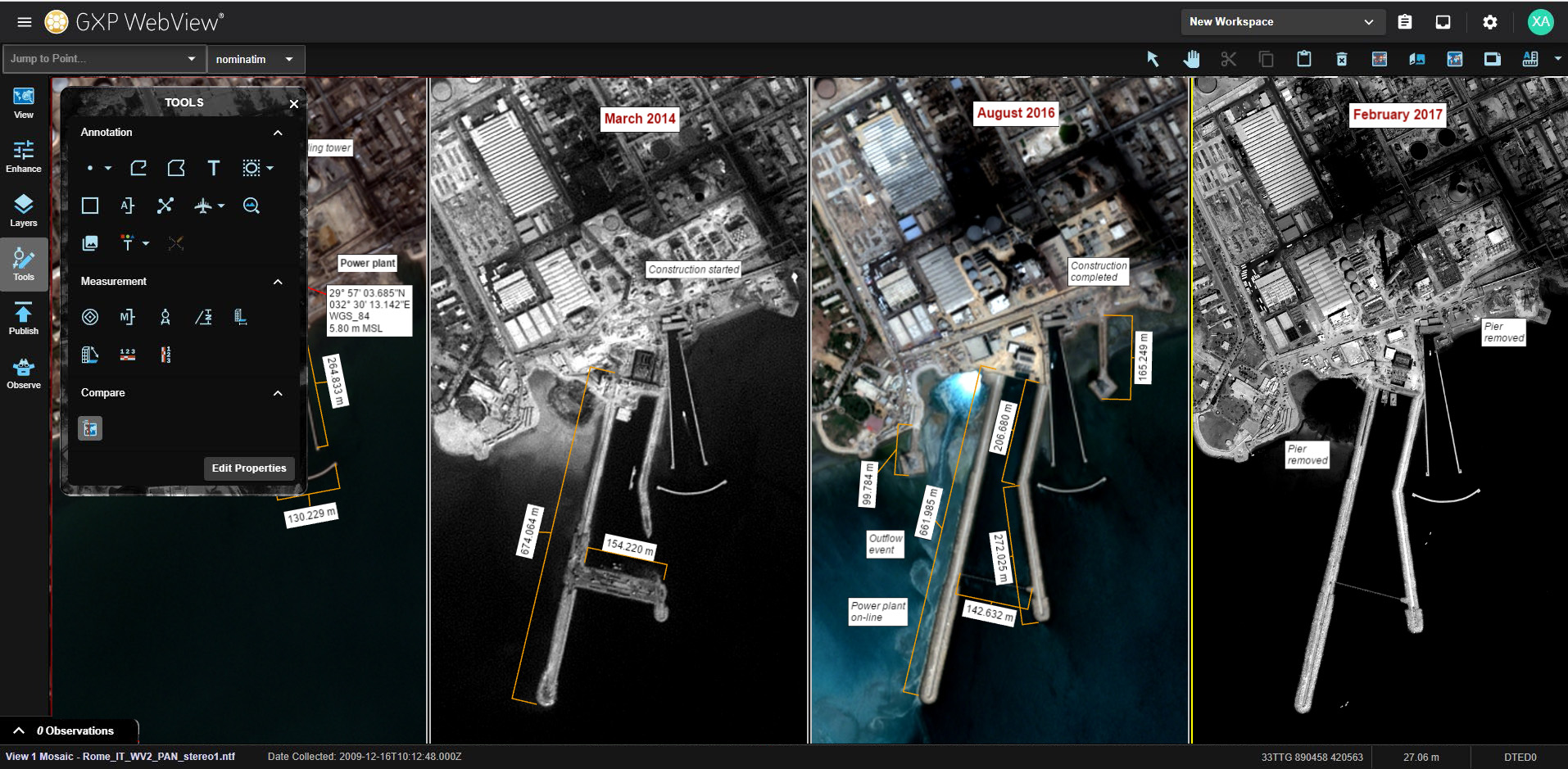
GXP WebView for targeting
GXP WebView delivers a web-based targeting application that streamlines the mensuration process while leveraging Common Geopositionining Services (CGS) for the derivation of coordinates and estimates of error. This addon capability enables targeteers to efficiently complete their tasks with full confidence in derived calculations and mission results.
- Imagery layout options including viewing up to four linked panels, virtual mosaics, and image lists that allow animation between layers
- Annotation tools (points, lines, polygons, text boxes, etc.)
- Precise coordinates including elevation derived from rigorous sensor models
- Support for a variety of coordinate systems including geographic, Universal Transverse Mercator (UTM), and Military Grid Reference System (MGRS)
- Range / bearing and bracket mensuration tools
- Object and shadow height measurement
- Save / restore workspaces
- Geospatial layer management including graphics, images, and Open Geospatial Consortium (OGC®) layers
- Customized templates for efficient product creation
- Product publishing to a variety of output formats and destinations including the GXP Xplorer catalog, PowerPoint, and KML
Integrated with the GXP Xplorer search capability, GXP WebView software provides the functionality to analyze and exploit imagery for detailed reporting and publication of finished GEOINT products.
GXP WebView Capabilities
View, measure, annotate, and disseminate geospatial image reports directly from a Web browser
The GXP WebView software solution is a light-weight Electronic Light Table (ELT) designed as a quick and easy tool for report creation and simple image viewing. Integrated with the GXP Xplorer search capability, the GXP WebView solution provides fast HTML 5 access to imagery of any format, as well as functionality to modify the image, exploit it, and publish the resulting finished product.
Annotation in a Web browser
- View image as if it were stored locally on your system
- Displays the optimal presentation of the image automatically
- Dynamically adjust imagery brightness, contrast, and sharpness in the browser as desired
- Draw lines, polygons, circles, and buffers
- Insert icons in many shapes and sizes (e.g., tanks, planes, markers)
- Enter text annotations
- Measure geographic coordinates using sensor model geometry, not approximations
- Underlying terrain used if available for geospatially correct measurements
- Measure distances and height calculations using sensor model
- Color-code every annotation and entry
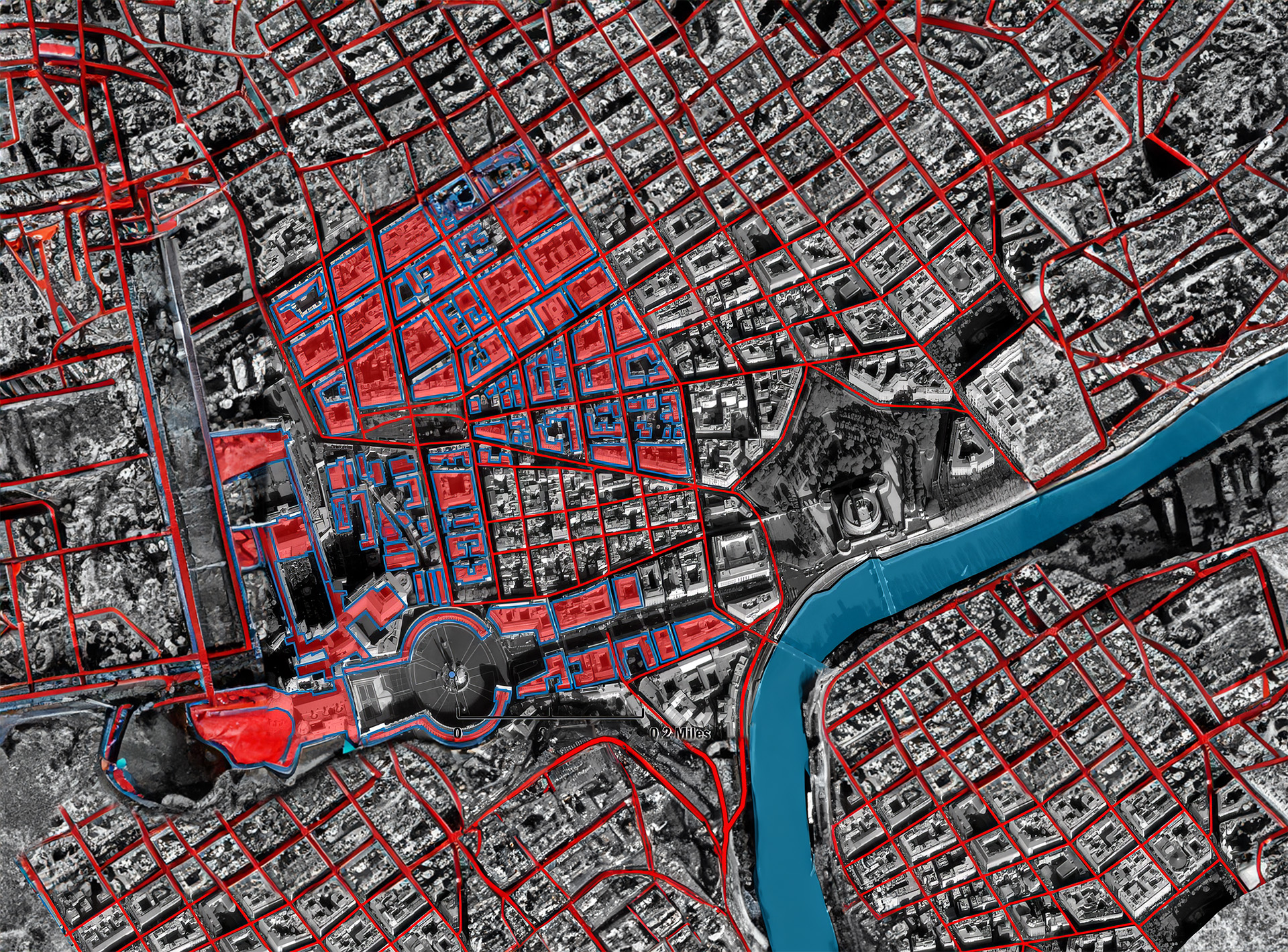
- Overlay a Web Feature Service (WFS) on the image for additional detail
- Load shapefiles to burn into the image report
- Collaborate via chat and jointly edit products in real time*
Publish
- Build the final brief in the Web browser
- Publish the annotated image product into PowerPoint®, GeoPDF®, PNG, and more
- Deliver via email and FTP
- Add the products to your GXP Xplorer catalog for subsequent use and availability
GXP® Pixel Streaming
GXP Pixel Streaming powers the GXP WebView solution’s capability to load full resolution images from GXP Xplorer catalogs and quickly turns any image, regardless of format or location, into a standards-based stream viewable in a Web browser.
- Delivers pixels from any image file format to the GXP WebView solution on-the-fly without reformatting to a new file
- Eliminate waiting for very large images to download
- Make Federation even more versatile by allowing direct access to products
- The SOCET GXP® software solution and other applications can integrate the GXP Pixel Streaming functionality
- Turn reference imagery into streamed backgrounds*
The GXP WebView solution is capable of creating 2D GeoPDF products
TerraGo® 2D GeoPDF Publisher for the GXP WebView solution allows for the creation of georegistered PDF files (GeoPDFs) from data loaded in the GXP WebView workspace. Different feature and data layers can be toggled on and off in the resultant GeoPDF product to allow for quickly filtering between relevant data.
Adding value to GXP workflows, GeoPDFs are interactive and easy-to-use products that can be shared with any end user including those on mobile devices. GeoPDFs can be freely viewed with the Adobe Acrobat Reader®. These products retain geographic coordinate information and thus are inherently more valuable than a standard PowerPoint slide or JPG file as they allow users to identify coordinates of items of interest and make measurements directly on the GeoPDF.
Benefits of GeoPDFs include
- Interact with imagery and location-based analysis
- Share with users on any devices including phones and tablets
- Measure length and area; display and locate coordinates
- Preserve data layers and toggle layer visibility
- Create and share location-based observations
The TerraGo Toolbar can be downloaded for free and allows users to view and track coordinates across the product, calculate measurements, create geospatial mark-ups, track real-time positions using GPS, and more.
GXP® Ecosystem
Providing the foundation for development of the most advanced geospatial intelligence, the GXP Ecosystem delivers an unrivaled capacity for discovery, exploitation, and dissemination of mission‑critical geospatial and temporal data.