GXP InMotion™ v2.6
A sleek, streamlined video analysis solution with a powerful set of tools designed for every workflow
Request additional info or a product demo
GXP InMotion™ Capabilities
Available in both desktop and server applications within the GXP® Ecosystem, GXP InMotion software delivers a streamlined user experience with a powerful set of tools designed for multiple levels of the motion GEOINT analysts’ needs – from simple viewing and screen capture to advanced video editing and exploitation.
Motion GEOINT Analysis and Intelligence Production
GXP InMotion offers a suite of multi-source video and analytic ISR solutions that enable automated processing of video and motion imagery while delivering real-time intelligence on movers (vehicles and people). These solutions are used by defenders worldwide to support critical missions.
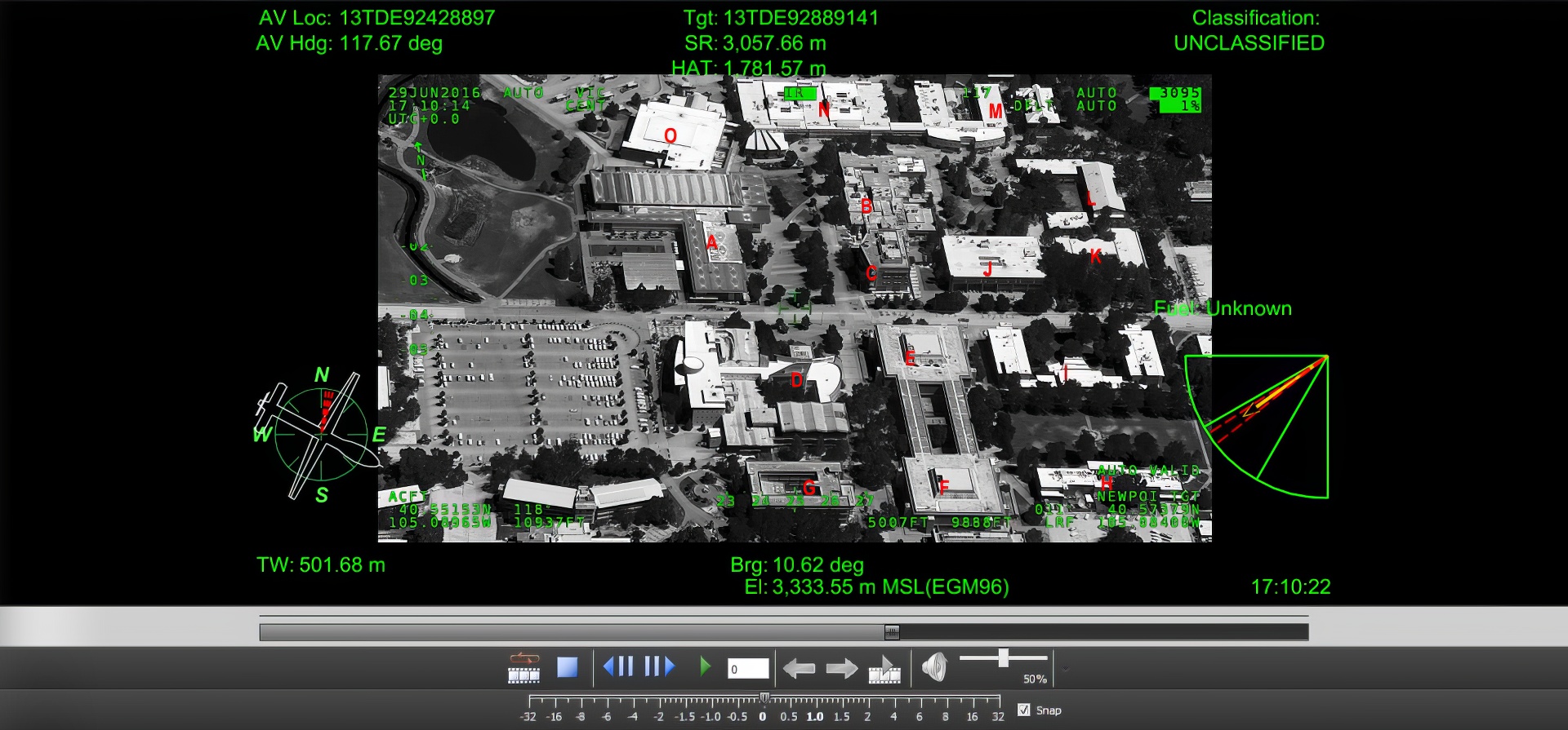
Full Motion Video (FMV)
Specifically designed to support real-time FMV missions that demand a focused, robust environment (e.g., mission oversight, confirmation of illicit activities, monitoring of ports and borders, surveillance), and delivers the extensive exploitation capabilities required for forensic analysis. A powerful, built-in sensor model establishes accurate geopositioning for real-time situational awareness, historical data analysis, and intelligence reporting.
Tracking Analytics Software Suite (TASS)
Enabling interpretation of critical movement and activity data from multiple sensor types, Tracking Analytics Software Suite (TASS) provides real-time detection and tracking of both vehicles and people across an entire field-of-view. From simple maneuvers, such as turns and acceleration, to object recognition, time-stamping, and geo-referencing, TASS offers unmatched intelligence and insight into targeted activities, and delivers a revolutionary means of exploiting motion imagery.
Wide Area Motion Imagery (WAMI)
Enabling interpretation of critical movement and activity data from multiple sensor types, GXP InMotion provides real-time detection and tracking of both vehicles and people across an entire field-of-view. From simple maneuvers, such as turns and acceleration, to object recognition, time-stamping, and geo-referencing, GXP InMotion offers unmatched intelligence and insight into targeted activities, and delivers a revolutionary means of exploiting motion imagery.
Moving Target Indication (MTI)
Unlock advanced situational awareness with our cutting-edge MTI analysis tools. Visualize and track targets with precision, leveraging features such as color-coded detections, individual point metadata, and temporal exploitation to reveal hidden patterns. With the ability to control trail display and distinguish between older detections, you can make informed decisions in real-time.
Developer Resources
The GXP DevKit contains C++, Python, and JavaScript® libraries that allow applications developed by third-parties to interact with the GXP software application through actions such as loading images, creating graphics, adding in image processing algorithms, and more.
Multiple Deployment Options
GXP InMotion Server
The GXP InMotion Server supports ingest and real-time streaming of video and Moving Target Indicator (MTI) feeds from airborne platforms and other sources, as well as video and GMTI recording, distributed mission management, restreaming, and enhanced collaboration among mission workgroups.
Enabling exploitation in an enterprise environment, the server solution allows organizations to efficiently scale based on the number of video missions (video or MTI) and analysts required.
GXP InMotion Desktop
The GXP InMotion Desktop application delivers extensive exploitation capabilities required for both real-time mission support and detailed forensic analysis. Platform tracking and image registration, as well as image enhancement and annotation, metadata overlays, advanced controls, and a built-in sensor model provide a robust environment for comprehensive video analysis.
GXP InMotion Web
GXP InMotion Web is a browser-based Motion Imagery and MOVINT solution suite that enables the entire enterprise to view and exploit both pixels and track data. Forensic videos can be investigated anywhere in the enterprise utilizing a Google Chrome, Mozilla Firefox, or Microsoft Edge browser. Quickly create a polished image product with a template from the template gallery, or send Image chips to GXP WebView for mensuration task or SOCET GXP desktop to create extended products including mosaics or 3D products. Video clips are intuitive to create and either save directly or send to the desktop for further video publishing needs.
Interoperability
Search and discovery
As part of the GXP Ecosystem, the GXP InMotion application also leverages the search and discovery power of GXP Xplorer®, integrated tracking services provided by the Tracking Analytics Software Suite (TASS), and the unparalleled image exploitation capabilities of SOCET GXP®. In addition, GXP InMotion integrates with Google Earth™ and ArcGIS® Earth mapping services to provide sensor position, field of view, and enhanced situational awareness.
Analysis and exploitation
GXP InMotion users can track platform movement in real time, while sensor modeling ensures that video coordinates are precisely matched to corresponding geographic ground coordinates. Motion imagery formats support detection overlays and image enhancements through adjustments in brightness, contrast, hue, sharpness, smoothing, and edge detection. Annotations can be placed directly on the motion imagery for export into multiple formats including KML and shapefiles.
Product creation
Users can efficiently combine or trim video clips, insert transitions and title slides, redact unwanted detail from the displayed metadata, and export resulting footage into standard video formats. Final products, from simple screen captures and full video segments, can then be developed with professional templates and superimposed video metadata such as position, heading, elevation, date, and time.
GXP® Ecosystem
Providing the foundation for development of the most advanced geospatial intelligence, the GXP Ecosystem delivers an unrivaled capacity for discovery, exploitation, and dissemination of mission‑critical geospatial and temporal data.